
Loowit Trail Day 1
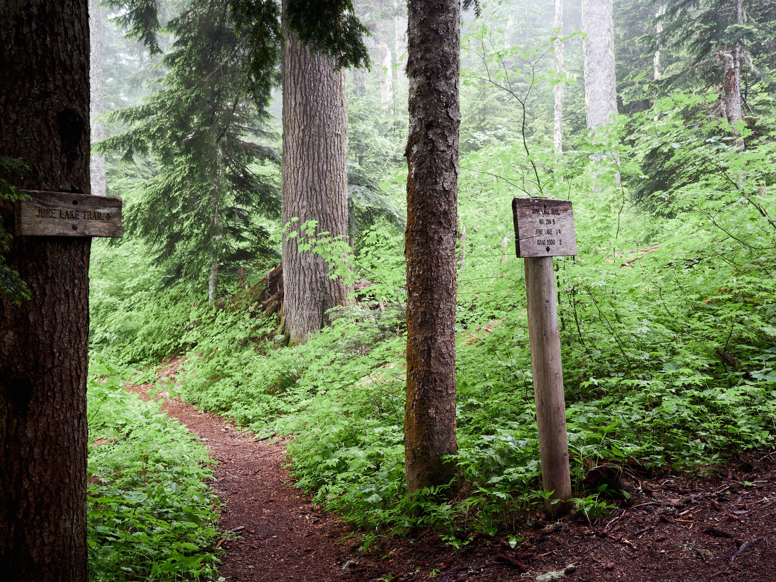
June Lake to Sheep Canyon
Hiking the Loowit Trail all the way around Mt Saint Helens is something that was on my mind and heart for many years.
Mt Saint Helens (Loowit by its native name from Puyallup tribes) holds a special and dear place in my heart. There have been many shared experiences with special people, successful summits, and beautiful views on this mountain. It has always recharged my spirits each time I set foot on it.
I didn’t know much about the trail other than “route-finding sections“ and “crossing canyons with ropes in them”. I knew there are about 30 miles of trail. I knew that water could be scarce certain times in the year. There is also limited camping in sections of the trail. The North blast zone is off limits for camping, so at least a 10-mile section of the trail must be done in a single day. The unknowns added just enough mystery and anxiety to keep me from doing it for some years.
Nearing the weekend of July 2, 2020, the stars aligned and set me off towards a Loowit adventure. I had three days off work to complete the hike, but I wanted to push myself. I had been feeling good with my physical conditioning recently, more so than I have in years, and I wanted to drain my physical batteries so to speak. I took enough food for three days, but was inclined to try it in two.
The initial plan was to start either on Monitor Ridge or June Lake, and attempting 2/3 of the hike in the first day, and completing it with an “easier“ finish on the second day. My final decision was set for a June Lake start, being lower elevation. This would give me a bit more elevation to gain at the start with fresh legs.
I kept my backpack weight as low as possible and made trade-offs between luxury items and essentials. I took 3lbs of camera gear, and another 1lb of what I consider my “electronics essentials“ — my Garmin InReach satellite communication and 10,000MAH battery charger. I left other “less-essentials” at home. The weather forecast had no precipitation on the horizon, so I left my rain pants and pack cover at home. I also left sandals and creature comforts behind. In all, my pack weighed 33lbs with food, water, shelter. This was my “light’ish“ setup, and I felt ready for the trail.
Between packing and anxious awakening, I managed to get 3 hours of sleep before setting off to Mt. Saint Helens in the early morning. I got up, showered, brewed my coffee, heated up snacks for the road, and made my way to the June Lake trailhead. I felt energized and ready despite the lack of sleep.

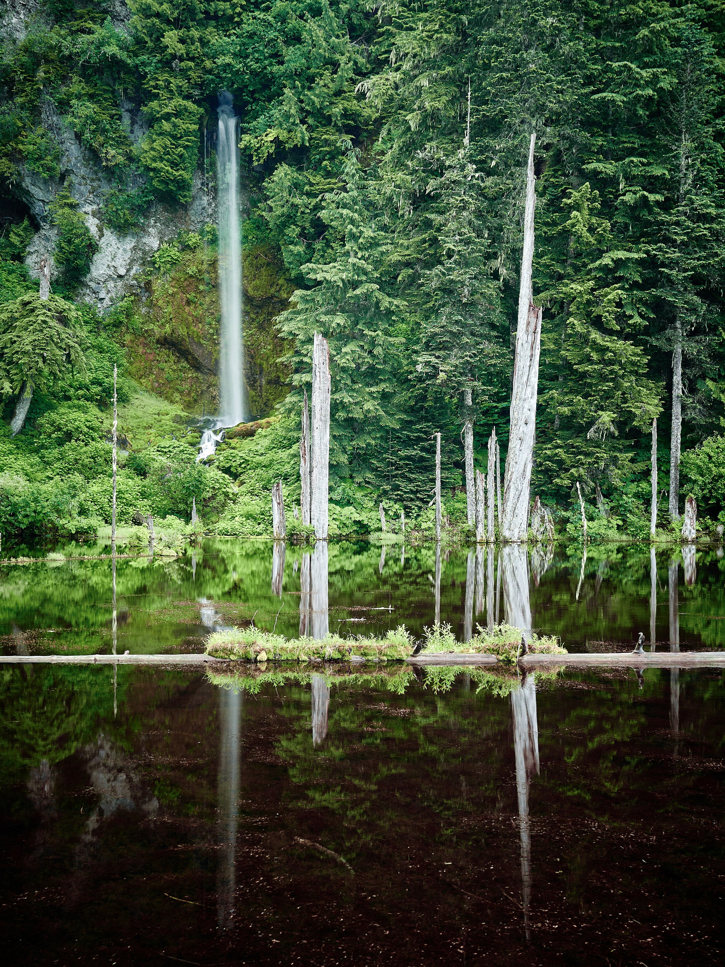
The June Lake trail starts off with a gradual ascent of 2 miles and 800ft elevation gain before reaching the trailhead’s namesake — June Lake itself. With still reflective waters, it was a good place for a short break. This lake was formed by a 2,000 year old lava flow, which blocked a tributary of Swift Creek. The logs and 70-foot waterfall paint a mysterious feel to this lake, and the sound of rushing waters enhance the senses.
After the short break at June Lake, I continued on upwards and clockwise around the mountain towards the Climber’s Bivouac junction. Droplets of water and mist blanketed the green canvas of foliage around me. The dew brushed against me in the thick foliage, and and I could feel the water soaking into my clothes. For a moment, I wondered if it was shortsighted to leave my rain gear and backpack cover behind. I reasoned that it was too late to regret this decision and embraced the morning mist brushing against my clothes.
In this early section of the hike, I met two older gentlemen who seemed to be knowledgeable of this mountain and the trails surrounding it. When I mentioned my plans and my destination, the older gentleman suggested that I camp at Sheep Canyon, sharing details on how to find the campsite. I made note of this suggestion.
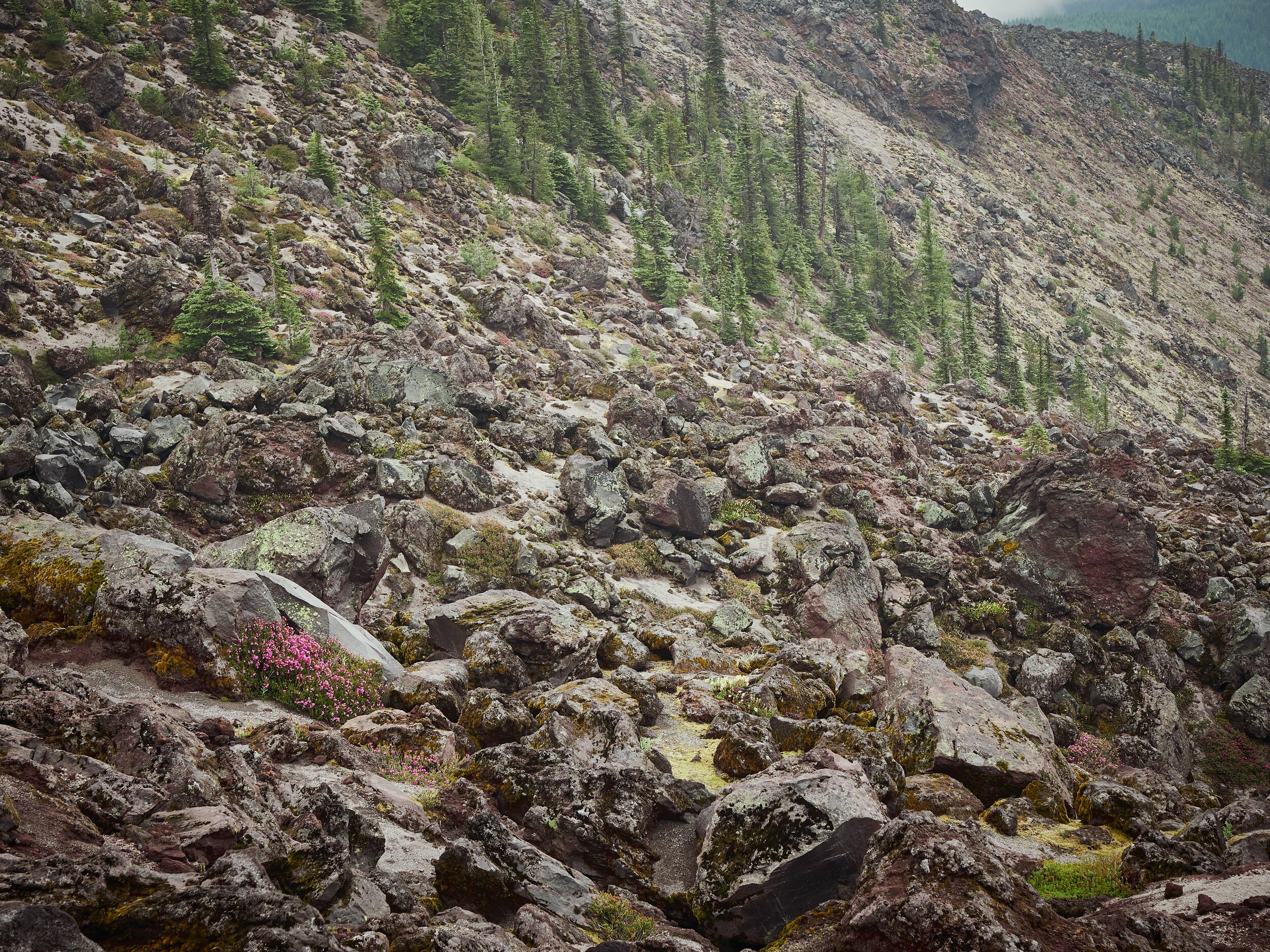
After another hour, I found myself on navigation challenges of continuously looking for the next “stick of wood“ marker on a sea of rocks. This was a “find your own adventure“ route, finding the best way to get to the next marker among thousands of boulders little and large. Some paths would prove to be a bit more difficult than others, and some would require me to backtrack and try again. I was grateful for the decent visibility despite the low clouds, I pressed on slowly, making progress with each step. There is a bit of fun in the process of looking for the next stick of wood and getting to it. You can only go so fast, and each step is intentional. You’re completely focused on your route, and with every step.


After the slow going crossing the boulder fields, reality set in that I likely wouldn’t be able to complete 2/3 of the trail on this first day. I dialed back my expectations and was content with camping near Sheep Canyon or South Toutle Fork river. With the fields cleared of boulders, I was able to make better progress.


Reaching the West side of the mountain, I crossed canyons and was met with bright green fields of vegetation teeming with life. One of these sheer canyons had a well-anchored rope that at first sight seemed to be good condition. It helped with the descent and ascent on both sides of the canyon. This barren land contrasted with the greenery surrounding it.


By this point, I had been hiking fast paced, for my own standards, for 7 hours with barely 3 hours of sleep. I noticed myself becoming half delirious, imagining an oasis for my arrival at campsite, with warm tea and fresh food awaiting.
On my delirious trek towards camp, I crossed a group of 3 hikers going the opposite way. I could tell by their aura that they had experience with long distance hiking. I would later find out this was indeed the case, having hiked the PCT just a couple of years prior. Their earned trail names, I would learn later, were Cherry Bomb, Guardian, and Swedish Chef. After a brief chat about the Loowit trail and our respective destinations, we continued on our way.
On my way down this last ridge of the day, I caught the first unclouded sights of Mt Saint Helens, and was soon descending 600ft towards my campsite, in search of sheep at Sheep Canyon. Once I arrived at camp, I was met with a luxurious space big enough for multiple tents, fresh water, and blooming wildflowers. My one-person tent was a cozy escape in this cush back-country campsite.


I filled up on water, heated up Miso soup, prepared dinner, did some light reading, and before long I was getting some much needed rest I needed for another day on the mountain.
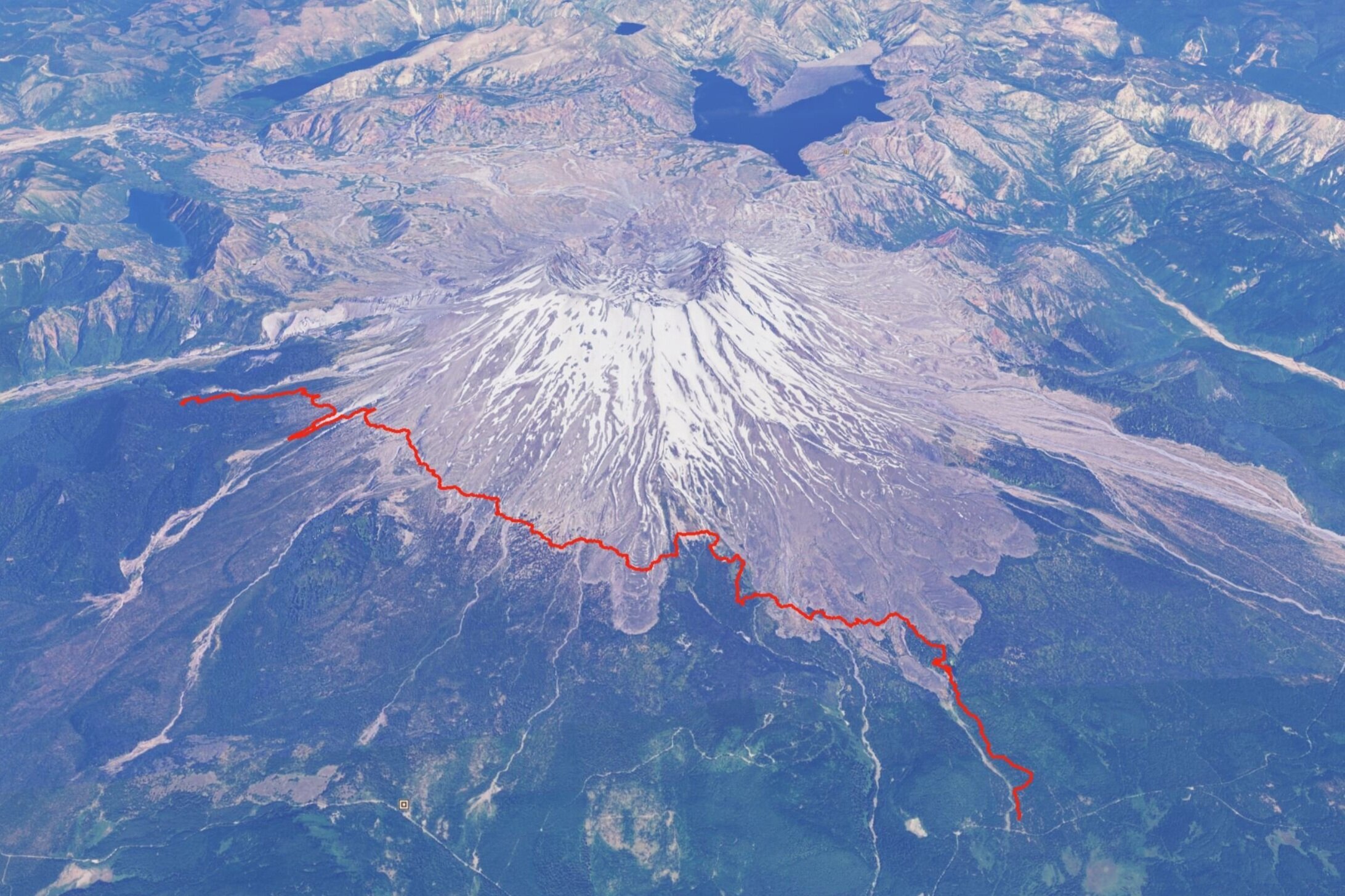
Distance: 12.3 miles
Duration: 9 hours 5 minutes
Elevation Gain — Loss: ▲ 3,043 ft — 2,055 ft ▼